
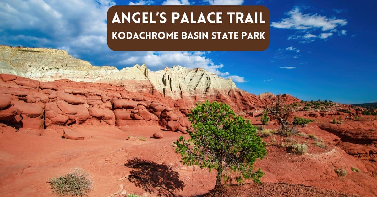
Hiking the Angels Palace Trail in Kodachrome
Kodachrome Basin State Park, located in southern Utah, is known for its colorful landscapes, towering spires, and tranquil desert beauty. Among its many hiking trails, the Angels Palace Trail in Kodachrome is a favorite for hikers seeking stunning vistas without an overly strenuous trek.
The Places Where We Go contains affiliate links and is a member of the Amazon Services LLC Associates Program. As an Amazon Associate, we earn from qualifying purchases at no extra cost to you when you purchase using one of these Amazon links. Read our disclaimer and privacy policy for more information.

Great trail! Would probably rate it as moderate. Hiking sticks might help going down. This is a great trail to just go and roam. The views are just awesome! You see a different side of Kodachrome from here.
Richard N. – An AllTrails Reviewer
Overview of the Angel’s Palace Trail
The Angel’s Palace Trail is a relatively short hike, about 1.5 miles round trip. For most hikers, the trail takes approximately one hour to complete, making it ideal for a half-day outing or as part of a more extensive day of exploration in the park. It has an elevation gain of about 150 feet, which adds a bit of adventure without being too physically demanding.

By The Numbers – Angel’s Palace Trail
Length: 1.5 miles
Elevation change: 223 feet
Difficulty rating: Easy to moderate
Type: Loop
Season: All year
Get Free Weekly Travel Planning Guide
Destination Ideas – Practical Tips – Timely Travel News

Who Will Enjoy This Hike?
This hike is perfect for beginner to moderate-level hikers, as the trail offers spectacular views with minimal technical difficulty. Families with children, casual hikers, and even those looking to dip their toes into hiking will find the Angels Palace Trail in Kodachrome manageable and rewarding. The trail is well-marked, but it features some narrow ridgelines and drop-offs, so anyone fearing heights might want to proceed cautiously.
More seasoned hikers will also enjoy this hike for its breathtaking panoramas, although they may wish to pair it with other trails in the park for a more intense workout.

What Hikers Love About Angel’s Palace Trail
The primary draw of the Angel’s Palace Trail is the incredible scenery. The elevated sections of the trail give hikers the feeling of being on top of the world as they take in sweeping views of Kodachrome Basin’s unique rock formations and the surrounding desert landscape. The colors of the red, orange, and white cliffs seem to shift throughout the day, making sunrise and sunset hikes particularly captivating.
Many hikers also appreciate the trail’s serenity. Kodachrome Basin tends to be less crowded than some of Utah’s other parks, allowing visitors to experience the natural beauty without large crowds.
In addition to the scenic vistas, Angel’s Palace offers plenty of opportunities for photography. The trail winds along ridges that provide a bird’s-eye view of the basin below, creating stunning photo opportunities at almost every turn.
Criticisms of the Hike
While the Angel’s Palace Trail is beloved for its beauty, it’s not without its criticisms. Some hikers feel the trail is too short and doesn’t offer enough challenge, particularly for those seeking more rigorous hikes. Others have mentioned that the trail can be narrow in places, which might be uncomfortable for people with a fear of heights.
The trail offers little shade during hot summer months, so hikers should be prepared with sun protection and plenty of water. The loose gravel on some sections of the trail can also make footing a bit precarious, so sturdy shoes are recommended.

Our Experience On The Grand Parade Trail
We hiked two trails during our visit to Kodachrome Basin State Park, Utah. First, we hiked the Grand Parade Trail. We next hopped into our car and probably drove no more than a minute or two to arrive at the trailhead for our next hike – the Angel’s Palace Trail.
Navigating The Hiking Trail
This trail diagram comes from Alltrails.com. The trail is listed as a loop. But, as you’ll read below about our confusion about finding the loop, you can see from the photo that the loop aspect isn’t exactly straightforward.

This hike is rated on the easier side of the scale. Still, we could see some folks noticing more of a challenge when compared to the nearby Grand Parade Trail. We would say this is more of a moderate hike. This trail presents a few inclines that may be challenging for some people.

Views From The Angel’s Palace Trail
After a modest effort to ascend the hilltop to a plateau and overlook. We see a landscape that reminds us of space scenes. There is desolation amidst interesting features. Some rocks take on smooth shapes formed by erosion over thousands or millions of years.
You will take in red rock hoodoos on this trail. After making the modest ascent on this hike, beautiful views reward the effort. Be sure to have your camera with you; after all, this is Kodachrome. The name sure means something. This trail provides great opportunities for photography and exploration. There are some great views and panoramas to be seen.

Geology of the Area
Similar to the terrain we explored earlier during the day while hiking the Grand Parade trail, this landscape features more cocoa-colored rocks and hills.
Standing on the plateau, the cocoa-colored rocks contrast the layered hills in the distance.

Trail Marker Confusion
Upon our ascent to the highest area of this trail, we noticed a variety of trail markers that pointed in different directions. However, several had become detached from their original position, making it somewhat confusing to determine which way to go. Some of the trail markers were toppled over. In some areas, there were trail paths without markers. We thought this was a loop but struggled to find a looping path. It was not just us who were confused. Other hikers we bumped into on the same afternoon were similarly disoriented. None of us could find exactly how the trail turned into a loop.


Caution and Warning Notes
Rock faces on the trail are noted to be extremely brittle and can give way without warning. It is recommended to stay back at least 10 feet from all drop-offs.

Returning to the Trailhead
After a bit of wondering and wandering, we decided to turn around and return in the same direction from where we started.

Back to the Campground
Camping sites are available directly within the park for those seeking a deeper exploration. We just scheduled a half-day visit to this park. After hiking two trails, we returned to our Airstream at the nearby Bryce Canyon RV Resort in Cannonville.
Plan For Your Hike
Check out the brochure from Kodachrome Basin State Park. It provides a Kodachrome Basin State Park map, trail maps, and information to help you plan to explore this area.
|
Explore Utah's Backcountry Trails
|
Find Your Perfect Utah Hike
|
Full-Color Travel Guide

|
|
Primary Rating:
4.7
|
Primary Rating:
4.8
|
Primary Rating:
4.6
|
|
$24.95
|
$20.88
|
$13.49
|
Listen to our Kodachrome Basin State Park Podcast Episode
Watch our YouTube video – Hiking at Kodachrome
Final Thoughts
Hiking Angel’s Palace Trail in Kodachrome made for a lovely afternoon hike. While the Grand Parade trail provides an excellent way to survey the flat areas of Kodachrome Basin State Park, this trail provides views from on high.
For visitors coming to nearby Bryce Canyon National Park, Kodachrome State Park offers many additional trails worth considering if you love hiking.
Whether you’re a seasoned hiker or just looking for a peaceful walk in a stunning landscape, the Angel’s Palace Trail in Kodachrome offers a beautiful, accessible way to experience the best of Kodachrome Basin State Park. Its picturesque vistas and manageable distance make it a must-do for anyone visiting the area. Just be sure to bring your camera and plenty of water!